Our updated public domain plan aims to enhance streets and public spaces in the northern parts of our city as major developments and new metro stations transform the area.
It responds to changes that will bring more people to the city's north, particularly in the area bounded by Martin Place and George, Bridge and Macquarie streets.
“We are committed to transforming Sydney into a greener, safer, calmer city – where communities can come together and our streets are destinations, rather than simply a means of transiting from one place to another,” Clover Moore, Lord Mayor of Sydney said.
"You only need look at the work we have done on George Street to see what’s possible. The conga-lines of buses on the clogged city street have been replaced by a beautiful tree-lined pedestrian boulevard through the heart of our city."
Opportunities to green and enhance public space
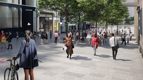
The city north public domain plan identifies opportunities to enhance the area, mainly centred around the unique precinct of Hunter Street and its surrounds.
The plan also commits to reflecting Aboriginal and Torres Strait Islander heritage and connections to Country. As projects progress, it will rebalance the representation of history and heritage in significant places.
Proposed projects include making the area better for people walking. They will also provide more opportunities for gathering and enhance the precinct’s unique character, including corner squares and heritage landmarks.
Ideas for consideration include:
- recognition of the historic Tank Stream watercourse under Hunter Street as part of a generous new public square
- share ways and pedestrian spaces on parts of Hunter, Spring, Loftus and O’Connell streets
- expanded public space from the southern edges of Chifley and Richard Johnson squares
- more trees and wider footpaths on Hunter, Gresham, Bent, Bligh and O’Connell streets.

The broader plan prioritises creating clutter-free walking routes. It also advocates for a public square at the water’s edge of Circular Quay.
Other proposals include:
- linked park and garden spaces from Circular Quay to the south
- reinforcing Martin Place as the city’s premier public space
- encouraging lively streets with activities spilling out from buildings into public space.
Expected growth and infrastructure to change area
About 16,000 more workers and 200 more homes are expected in the city’s north by 2025. New metro stations are due to for completion at Martin Place and Pitt Street next year. A new station is also planned for Hunter Street. It's set to be the busiest interchange in central Sydney when finished in 2030.
The City of Sydney's public domain plan was first drafted in 2015. The updated plan was open for feedback last year and was adopted by Council on Monday 13 March.
“Sydney is constantly evolving and big changes can’t be made in isolation. It’s vital we have plans like this to guide not just our planners but government and developers as we take the city into the future," the Lord Mayor said.
Published 22 March 2023, updated 10 April 2024